What You Are Actually Seeing
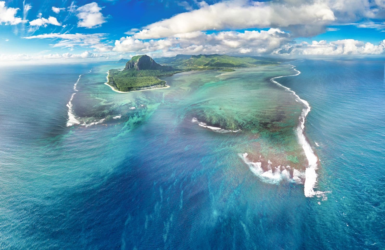
Seen from above, the sea off the Le Morne peninsula appears to pour over the edge of an underwater cliff — a waterfall inside the ocean. It is one of the most shared aerial images of Mauritius, and it is an illusion.
No water is falling. Sand and silt from the shallow coastal shelf are being pushed by currents over the edge of that shelf, streaming down toward deeper water. From altitude, the moving sediment reads as a cascade.
Why It Happens Here
Mauritius stands on a shallow submarine platform. Around most of the island, the seabed slopes away gradually — but off the southwestern tip, beyond Le Morne, the shelf ends and the floor falls away steeply toward the deep ocean.
The lagoon side stays bright turquoise because it is only a few meters deep. Immediately beyond the shelf edge, the water turns abruptly dark. The sediment streaming across that boundary creates the waterfall shape, constantly redrawn by the currents.
How To See It
The full effect needs altitude. Helicopter and seaplane sightseeing flights over the southwest are the classic way to see it, and the reason most photos of it exist.
From the summit of Le Morne Brabant you can see the color boundary and, in the right light, a suggestion of the streaming shape — worth knowing if you are hiking anyway, but it is not the aerial image.
The cheapest view is the satellite one: find Le Morne on any mapping app's satellite layer and the illusion is right there. That image is what made the phenomenon famous.
Can You Swim Or Dive It?
No — and there is nothing to dive. The 'waterfall' is an appearance created by sediment moving at and beyond the shelf edge, in open water with real current, outside the reef. The lagoon inside the reef is the swimming water; the shelf edge is not.
Planning Around It
A flight over the underwater waterfall pairs naturally with the rest of the southwest: the mountain, the lagoon, Chamarel, and the coast road. Clear, calm mornings give the strongest colors; big swell and stirred-up water soften the effect.
If a flight is out of budget, do the summit-plus-satellite combination on a clear day and spend the difference on the rest of the peninsula.
Frequently Asked Questions
Is the underwater waterfall real?
It is a real, photographable phenomenon — but it is an optical illusion. Currents drag sand and silt off the shallow shelf toward deep water, and from above the moving sediment looks like a waterfall.
Can you see it from Le Morne Brabant?
Partially. From the summit you can see the sharp color boundary between lagoon and deep ocean and sometimes a hint of the streaming shape. The full waterfall image needs an aerial view.
How do I see it properly?
Helicopter or seaplane sightseeing flights over the southwest are the standard way. The satellite layer of any mapping app shows the same illusion for free.
Can you dive or snorkel the underwater waterfall?
No. It is not a physical structure you can visit — it is sediment moving over the shelf edge into deep, open water beyond the reef. Swim and snorkel inside the lagoon instead.
Where exactly is it?
Off the southwestern tip of Mauritius, immediately beyond the reef at the Le Morne peninsula, where the shallow shelf meets the deep ocean.
Make it a southwest day
Pair the aerial view with the mountain, the lagoon, and Chamarel in one plan.